Skip to search
Skip to main content
Skip to first result
Skip to matching collections
Skip to limit your search
Skip to search
Duke University Libraries
Repository
Collections & Archives
Search
{:label=>"Search"}
Login
Ask
Menu
Menu
Login
Ask a Librarian
Search & Find
Using the Library
Research Support
Course Support
Libraries
About
Search
Search Constraints
New Search
You searched for:
Collection Group
Data and Visualization Services
✖
Remove constraint Collection Group: Data and Visualization Services
Year
1950
to
1959
✖
Remove constraint Year: <span class="from" data-blrl-begin="1950">1950</span> to <span class="to" data-blrl-end="1959">1959</span>
Matching Collections (6) »
1.
Euratlas Historical Political Boundaries of Europe
2.
Historic Digital Bills and Resolutions: 1789-2013
3.
Duke Forest GIS Layers
1
-
20
of
20
Sort
by date (old to new)
relevance
title
date (old to new)
date (new to old)
Number of results to display per page
20
per page
per page
10
per page
20
per page
50
per page
100
per page
View results as:
List
List
Gallery
Gallery
Search Results
1.
Euratlas Historical Political Boundaries of Europe
Date:
1 to 2000
Format:
TXT; HTML; ZIP
2.
Historic Digital Bills and Resolutions: 1789-2013
Date:
1789 to 2013
Format:
TAR; XML; DOCX; PDF
3.
Duke Forest GIS Layers
Date:
1931; 1944; 1952; 1963; 1975; 1986
Format:
ZIP; HTML; KMZ; JPEG
4.
Defense Casualty Analysis System Dataset
Creator:
National Archives and Records Administration
Date:
June 28, 1950 to May 28, 2006
Format:
DAT; XLS
5.
Defense Casualty Analysis System Dataset
Creator:
National Archives and Records Administration
Date:
June 28, 1950 to May 28, 2006
Collection:
Defense Casualty Analysis System Dataset
6.
Standings, Durham Division - 1952
Date:
1952
Collection:
Duke Forest GIS Layers
7.
Standings, Blackwood Division - 1952
Date:
1952
Collection:
Duke Forest GIS Layers
8.
Plantations - 1952
Date:
1952
Collection:
Duke Forest GIS Layers
9.
Disturbances - 1952
Date:
1952
Collection:
Duke Forest GIS Layers
10.
Cultural Operations - 1952
Date:
1952
Collection:
Duke Forest GIS Layers
11.
Standings, Henry J. Oosting Natural Area - 1952
Date:
1952
Collection:
Duke Forest GIS Layers
12.
Harvestings - 1952
Date:
1952
Collection:
Duke Forest GIS Layers
13.
Standings, Hillsboro Division - 1952
Date:
1952
Collection:
Duke Forest GIS Layers
14.
Standings, Korstian Division - 1952
Date:
1952
Collection:
Duke Forest GIS Layers
15.
Standings, Eno Division - 1952
Date:
1952
Collection:
Duke Forest GIS Layers
16.
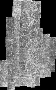
Durham Aerial Imagery (USDA)
Date:
1955; 1960; 1966 to 1967
Format:
KMZ; GIF; JPEG
17.
Durham Aerial Imagery (USDA) - Index Images and Grids for Image Selection
Date:
1955; 1960; 1966
Collection:
Durham Aerial Imagery (USDA)
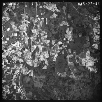
18.
Durham Aerial Imagery (USDA) - 1955
Date:
March 30, 1955; April 16, 1955
Collection:
Durham Aerial Imagery (USDA)
19.
Combat Area Casualties Dataset
Creator:
National Archives and Records Administration
Date:
August 6, 1956 to January 21, 1998
Format:
TXT; XLS
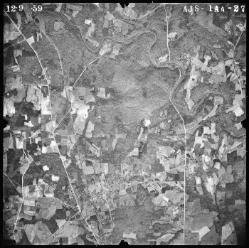
20.
Durham Aerial Imagery (USDA) - 1960
Date:
December 9, 1959; January 9, 1960; January 15, 1960; January 23, 1960
Collection:
Durham Aerial Imagery (USDA)
Limit your search
Collection Group
Data and Visualization Services
✖
[remove]
20
Collection
Duke Forest GIS Layers
11
Durham Aerial Imagery (USDA)
4
Defense Casualty Analysis System Dataset
2
Combat Area Casualties Dataset
1
Euratlas Historical Political Boundaries of Europe
1
more
Collection
»
Year
1950
to
1959
✖
[remove]
20
1950
4
1951
4
1952
15
1953
4
1954
4
1955
7
1956
5
1957
5
1958
5
1959
6
Current results range from
1000
to
2013
Year range begin
Year range end
View larger »
Creator
National Archives and Records Administration
3
Format
HTML
2
JPEG
2
KMZ
2
TXT
2
XLS
2
more
Format
»
Subject
Bills, Legislative
1
Korean War
1
Legislation
1
Military casualties
1
Military casualties--Korean War
1
more
Subject
»
Language
English
7
Location
United States
16
North Carolina
15
Cambodia
3
China
3
Durham (N.C.)
3
more
Location
»
Collecting Area
Center for Data and Visualization Sciences
6
Contact us
Contact us
×